Hinckley and Bosworth
| Niet-metropolitaans district in Engeland | |||
|---|---|---|---|
| |||
| Situering | |||
| Land | Engeland | ||
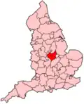
| County | Leicestershire | ||
| Regio | East Midlands | ||
| Coördinaten | 52°36'45"NB, 1°21'13"WL | ||
| Algemeen | |||
| Oppervlakte | 297,3492[1] km² | ||
| Inwoners (2018[2]) |
112.423 (378 inw./km²) | ||
| ONS-code | E07000132 | ||
| Website | www | ||
| Detailkaart | |||
| |||
| |||
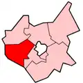
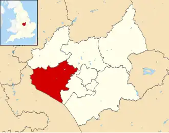
Hinckley and Bosworth is een Engels district in het shire-graafschap (non-metropolitan county OF county) Leicestershire en telt 112.000 inwoners. De oppervlakte bedraagt 297 km².
Van de bevolking is 16,0% ouder dan 65 jaar. De werkloosheid bedraagt 2,5% van de beroepsbevolking (cijfers volkstelling 2001).
Plaatsen in district Hinckley and Bosworth
Civil parishes in district Hinckley and Bosworth
Bagworth & Thornton, Barlestone, Barwell, Burbage, Cadeby, Carlton, Desford, Earl Shilton, Groby, Higham on the Hill, Market Bosworth, Markfield, Nailstone, Newbold Verdon, Osbaston, Peckleton, Ratby, Shackerstone, Sheepy, Stanton-under-Bardon, Stoke Golding, Sutton Cheney, Twycross, Witherley.
Bronnen, noten en/of referenties
- ↑ Office for National Statistics → Download → SAM_for_Administrative_Areas_(2018).zip → SAM_LAD_DEC_2018_UK.xlsx. Gearchiveerd op 12 juni 2023.
- ↑ https://www.ons.gov.uk/file?uri=/peoplepopulationandcommunity/populationandmigration/populationestimates/datasets/populationestimatesforukenglandandwalesscotlandandnorthernireland/mid20182019laboundaries/ukmidyearestimates20182019ladcodes.xls Schatting Office for National Statistics: knop MYE5 → kolom Estimated Population mid-2018]