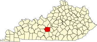
Hart County (Kentucky)
| County in de Verenigde Staten | |||
|---|---|---|---|
| |||
| Situering | |||
| Staat | Kentucky | ||
| Coördinaten | 37°17'24"NB, 85°53'24"WL | ||
| Algemeen | |||
| Oppervlakte | 1.082 km² | ||
| - land | 1.077 km² | ||
| - water | 5 km² | ||
| Inwoners (2000) |
17.445 (16 inw./km²) | ||
| Overig | |||
| Zetel | Munfordville | ||
| FIPS-code | 21099 | ||
| Opgericht | 1819 | ||
| Website | www | ||
| Foto's | |||

| |||
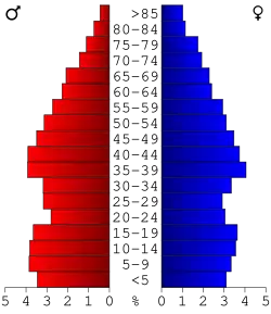 Bevolkingspiramide Hart County | |||
| Statistieken volkstelling Hart County | |||
| |||
Hart County is een county in de Amerikaanse staat Kentucky.
De county heeft een landoppervlakte van 1.077 km² en telt 17.445 inwoners (volkstelling 2000). De hoofdplaats is Munfordville en de dichtstbevolkte stad is Horse Cave.
Bevolkingsontwikkeling
| Jaar | Inwoners | % ± | |
|---|---|---|---|
| 1900 | 18.390 | — | |
| 1910 | 18.173 | −1,2% | |
| 1920 | 18.544 | 2,0% | |
| 1930 | 16.169 | −12,8% | |
| 1940 | 17.239 | 6,6% | |
| 1950 | 15.321 | −11,1% | |
| 1960 | 14.119 | −7,8% | |
| 1970 | 13.980 | −1,0% | |
| 1980 | 15.402 | 10,2% | |
| 1990 | 14.890 | −3,3% | |
| 2000 | 17.445 | 17,2% | |
| Bron: (en) Historical Decennial Census Population | |||