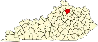
Harrison County (Kentucky)
| County in de Verenigde Staten | |||
|---|---|---|---|
| |||
| Situering | |||
| Staat | Kentucky | ||
| Coördinaten | 38°26'24"NB, 84°19'48"WL | ||
| Algemeen | |||
| Oppervlakte | 803 km² | ||
| - land | 802 km² | ||
| - water | 1 km² | ||
| Inwoners (2000) |
17.983 (22 inw./km²) | ||
| Overig | |||
| Zetel | Cynthiana | ||
| FIPS-code | 21097 | ||
| Opgericht | 1793 | ||
| Website | www | ||
| Foto's | |||

| |||
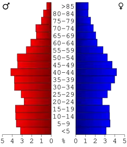 Bevolkingspiramide Harrison County | |||
| Statistieken volkstelling Harrison County | |||
| |||
Harrison County is een county in de Amerikaanse staat Kentucky.
De county heeft een landoppervlakte van 802 km² en telt 17.983 inwoners (volkstelling 2000). De hoofdplaats is Cynthiana.
Bevolkingsontwikkeling
| Jaar | Inwoners | % ± | |
|---|---|---|---|
| 1900 | 18.570 | — | |
| 1910 | 16.873 | −9,1% | |
| 1920 | 15.798 | −6,4% | |
| 1930 | 14.859 | −5,9% | |
| 1940 | 15.124 | 1,8% | |
| 1950 | 13.736 | −9,2% | |
| 1960 | 13.704 | −0,2% | |
| 1970 | 14.158 | 3,3% | |
| 1980 | 15.166 | 7,1% | |
| 1990 | 16.248 | 7,1% | |
| 2000 | 17.983 | 10,7% | |
| Bron: (en) Historical Decennial Census Population | |||