Harford County
| County in de Verenigde Staten | |||
|---|---|---|---|
| |||
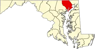
| Situering | |||
| Staat | Maryland | ||
| Coördinaten | 39°32'24"NB, 76°18'0"WL | ||
| Algemeen | |||
| Oppervlakte | 1.365 km² | ||
| - land | 1.141 km² | ||
| - water | 224 km² | ||
| Inwoners (2000) |
218.590 (192 inw./km²) | ||
| Overig | |||
| Zetel | Bel Air | ||
| FIPS-code | 24025 | ||
| Opgericht | 1773 | ||
| Website | www | ||
| Foto's | |||

| |||
 Bevolkingspiramide Harford County | |||
| Statistieken volkstelling Harford County | |||
| |||
Harford County is een county in de Amerikaanse staat Maryland.
De county heeft een landoppervlakte van 1.141 km² en telt 218.590 inwoners (volkstelling 2000). De hoofdplaats is Bel Air.
Bevolkingsontwikkeling
| Jaar | Inwoners | % ± | |
|---|---|---|---|
| 1900 | 28.269 | — | |
| 1910 | 27.965 | −1,1% | |
| 1920 | 29.291 | 4,7% | |
| 1930 | 31.603 | 7,9% | |
| 1940 | 35.060 | 10,9% | |
| 1950 | 51.782 | 47,7% | |
| 1960 | 76.722 | 48,2% | |
| 1970 | 115.378 | 50,4% | |
| 1980 | 145.930 | 26,5% | |
| 1990 | 182.132 | 24,8% | |
| 2000 | 218.590 | 20,0% | |
| Bron: (en) Historical Decennial Census Population | |||