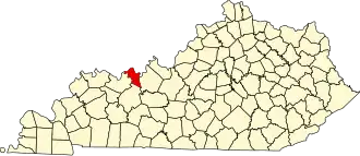
Hancock County (Kentucky)
| County in de Verenigde Staten | |||
|---|---|---|---|
| |||
| Situering | |||
| Staat | Kentucky | ||
| Coördinaten | 37°50'24"NB, 86°46'48"WL | ||
| Algemeen | |||
| Oppervlakte | 515 km² | ||
| - land | 489 km² | ||
| - water | 26 km² | ||
| Inwoners (2000) |
8.392 (17 inw./km²) | ||
| Overig | |||
| Zetel | Hawesville | ||
| FIPS-code | 21091 | ||
| Opgericht | 1829 | ||
| Website | www | ||
| Foto's | |||

| |||
 Bevolkingspiramide Hancock County | |||
| Statistieken volkstelling Hancock County | |||
| |||
Hancock County is een county in de Amerikaanse staat Kentucky.
De county heeft een landoppervlakte van 489 km² en telt 8.392 inwoners (volkstelling 2000). De hoofdplaats is Hawesville en de dichtstbevolkte stad is Lewisport.
Bevolkingsontwikkeling
| Jaar | Inwoners | % ± | |
|---|---|---|---|
| 1900 | 8.914 | — | |
| 1910 | 8.512 | −4,5% | |
| 1920 | 6.945 | −18,4% | |
| 1930 | 6.147 | −11,5% | |
| 1940 | 6.807 | 10,7% | |
| 1950 | 6.009 | −11,7% | |
| 1960 | 5.330 | −11,3% | |
| 1970 | 7.080 | 32,8% | |
| 1980 | 7.742 | 9,4% | |
| 1990 | 7.864 | 1,6% | |
| 2000 | 8.392 | 6,7% | |
| Bron: (en) Historical Decennial Census Population | |||