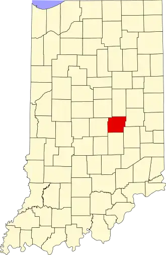
Hancock County (Indiana)
| County in de Verenigde Staten | |||
|---|---|---|---|
| |||
| Situering | |||
| Staat | Indiana | ||
| Coördinaten | 39°49'12"NB, 85°46'12"WL | ||
| Algemeen | |||
| Oppervlakte | 795 km² | ||
| - land | 793 km² | ||
| - water | 2 km² | ||
| Inwoners (2000) |
55.391 (70 inw./km²) | ||
| Overig | |||
| Zetel | Greenfield | ||
| FIPS-code | 18059 | ||
| Opgericht | 1827 | ||
| Website | www | ||
| Foto's | |||

| |||
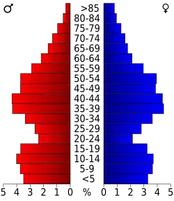 Bevolkingspiramide Hancock County | |||
| Statistieken volkstelling Hancock County | |||
| |||
Hancock County is een county in de Amerikaanse staat Indiana.
De county heeft een landoppervlakte van 793 km² en telt 55.391 inwoners (volkstelling 2000). De hoofdplaats is Greenfield.
Bevolkingsontwikkeling
| Jaar | Inwoners | % ± | |
|---|---|---|---|
| 1900 | 19.189 | — | |
| 1910 | 19.030 | −0,8% | |
| 1920 | 17.210 | −9,6% | |
| 1930 | 16.605 | −3,5% | |
| 1940 | 17.302 | 4,2% | |
| 1950 | 20.332 | 17,5% | |
| 1960 | 26.665 | 31,1% | |
| 1970 | 35.096 | 31,6% | |
| 1980 | 43.939 | 25,2% | |
| 1990 | 45.527 | 3,6% | |
| 2000 | 55.391 | 21,7% | |
| Bron: (en) Historical Decennial Census Population | |||