Gunnison County
| County in de Verenigde Staten | |||
|---|---|---|---|

| |||
| Situering | |||
| Staat | Colorado | ||
| Coördinaten | 38°40'12"NB, 107°0'36"WL | ||
| Algemeen | |||
| Oppervlakte | 8.442 km² | ||
| - land | 8.388 km² | ||
| - water | 54 km² | ||
| Inwoners (2000) |
13.956 (2 inw./km²) | ||
| Overig | |||
| Zetel | Gunnison | ||
| FIPS-code | 08051 | ||
| Opgericht | 1877 | ||
| Website | www | ||
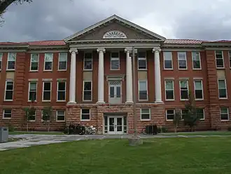
| Foto's | |||
| |||
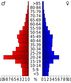 Bevolkingspiramide Gunnison County | |||
| Statistieken volkstelling Gunnison County | |||
| |||
Gunnison County is een county in de Amerikaanse staat Colorado.
De county heeft een landoppervlakte van 8.388 km² en telt 13.956 inwoners (volkstelling 2000). De hoofdplaats is Gunnison.
Bevolkingsontwikkeling
| Jaar | Inwoners | % ± | |
|---|---|---|---|
| 1900 | 5.331 | — | |
| 1910 | 5.897 | 10,6% | |
| 1920 | 5.590 | −5,2% | |
| 1930 | 5.527 | −1,1% | |
| 1940 | 6.192 | 12,0% | |
| 1950 | 5.716 | −7,7% | |
| 1960 | 5.477 | −4,2% | |
| 1970 | 7.578 | 38,4% | |
| 1980 | 10.689 | 41,1% | |
| 1990 | 10.273 | −3,9% | |
| 2000 | 13.956 | 35,9% | |
| Bron: (en) Historical Decennial Census Population | |||