Graham County (Arizona)
| County in de Verenigde Staten | |||
|---|---|---|---|
| |||
| Situering | |||
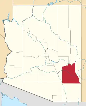
| Staat | Arizona | ||
| Coördinaten | 33°2'24"NB, 109°46'48"WL | ||
| Algemeen | |||
| Oppervlakte | 12.021 km² | ||
| - land | 11.990 km² | ||
| - water | 31 km² | ||
| Inwoners (2000) |
33.489 (3 inw./km²) | ||
| Overig | |||
| Zetel | Safford | ||
| FIPS-code | 04009 | ||
| Opgericht | 1881 | ||
| Website | www | ||
| Foto's | |||

| |||
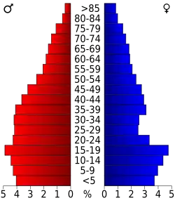 Bevolkingspiramide Graham County | |||
| Statistieken volkstelling Graham County | |||
| |||
Graham County is een county in de Amerikaanse staat Arizona.
De county heeft een landoppervlakte van 11.990 km² en telt 33.489 inwoners (volkstelling 2000). De hoofdplaats is Safford.
Bevolkingsontwikkeling
| Jaar | Inwoners | % ± | |
|---|---|---|---|
| 1900 | 14.162 | — | |
| 1910 | 23.999 | 69,5% | |
| 1920 | 10.148 | −57,7% | |
| 1930 | 10.373 | 2,2% | |
| 1940 | 12.113 | 16,8% | |
| 1950 | 12.985 | 7,2% | |
| 1960 | 14.045 | 8,2% | |
| 1970 | 16.578 | 18,0% | |
| 1980 | 22.862 | 37,9% | |
| 1990 | 26.554 | 16,1% | |
| 2000 | 33.489 | 26,1% | |
| Bron: (en) Historical Decennial Census Population | |||