Gory Gopéla
| Commune in Mali | |||
|---|---|---|---|
 | |||
| |||
| Situering | |||
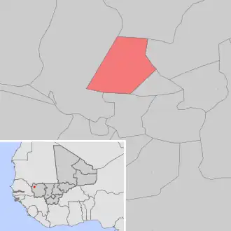
| Regio | Kayes | ||
| Cercle | Kayes | ||
| Coördinaten | 14° 43′ NB, 11° 21′ WL | ||
| Algemeen | |||
| Oppervlakte | 330,30 km² | ||
| Inwoners (2009[1]) |
7866 (24 inw./km²) | ||
| Hoogte | 65 m | ||
| |||
Gory Gopéla is een gemeente (commune) in de regio Kayes in Mali. De gemeente telt 7900 inwoners (2009).
De gemeente bestaat uit de volgende plaatsen:
- Bougountinti
- Dag-Dag
- Gory Gopéla
- Koumaréfara
- Tichy-Gansoye
Bronnen, noten en/of referenties