Geary County
| County in de Verenigde Staten | |||
|---|---|---|---|
| |||
| Situering | |||
| Staat | Kansas | ||
| Coördinaten | 38°54'31"NB, 96°45'8"WL | ||
| Algemeen | |||
| Oppervlakte | 1.047 km² | ||
| - land | 996 km² | ||
| - water | 51 km² | ||
| Inwoners (2000) |
27.947 (28 inw./km²) | ||
| Overig | |||
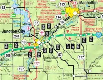
| Zetel | Junction City | ||
| FIPS-code | 20061 | ||
| Opgericht | 1855 | ||
| Website | www | ||
| Detailkaart | |||
| |||
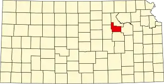
| Overzichtskaart van Geary County | |||
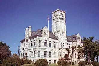
| Foto's | |||
| |||
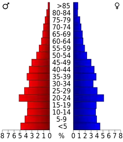 Bevolkingspiramide Geary County | |||
| Statistieken volkstelling Geary County | |||
| |||
Geary County is een county in de Amerikaanse staat Kansas.
De county heeft een landoppervlakte van 996 km² en telt 27.947 inwoners (volkstelling 2000). De hoofdplaats is Junction City.
Bevolkingsontwikkeling
| Jaar | Inwoners | % ± | |
|---|---|---|---|
| 1900 | 10.744 | — | |
| 1910 | 12.681 | 18,0% | |
| 1920 | 13.452 | 6,1% | |
| 1930 | 14.366 | 6,8% | |
| 1940 | 15.222 | 6,0% | |
| 1950 | 21.671 | 42,4% | |
| 1960 | 28.779 | 32,8% | |
| 1970 | 28.111 | −2,3% | |
| 1980 | 29.852 | 6,2% | |
| 1990 | 30.453 | 2,0% | |
| 2000 | 27.947 | −8,2% | |
| Bron: (en) Historical Decennial Census Population | |||