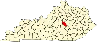
Garrard County
| County in de Verenigde Staten | |||
|---|---|---|---|
| |||
| Situering | |||
| Staat | Kentucky | ||
| Coördinaten | 37°38'22,49"NB, 84°32'15,47"WL | ||
| Algemeen | |||
| Oppervlakte | 606 km² | ||
| - land | 599 km² | ||
| - water | 7 km² | ||
| Inwoners (2000) |
14.792 (25 inw./km²) | ||
| Overig | |||
| Zetel | Lancaster | ||
| FIPS-code | 21079 | ||
| Opgericht | 1796 | ||
| Website | garrardcounty | ||
| Foto's | |||

| |||
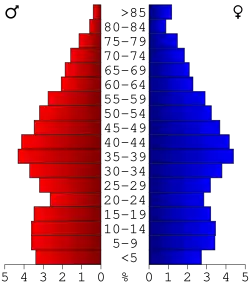 Bevolkingspiramide Garrard County | |||
| Statistieken volkstelling Garrard County | |||
| |||
Garrard County is een county in de Amerikaanse staat Kentucky.
De county heeft een landoppervlakte van 599 km² en telt 14.792 inwoners (volkstelling 2000). De hoofdplaats is Lancaster.
Bevolkingsontwikkeling
| Jaar | Inwoners | % ± | |
|---|---|---|---|
| 1900 | 12.042 | — | |
| 1910 | 11.894 | −1,2% | |
| 1920 | 12.503 | 5,1% | |
| 1930 | 11.562 | −7,5% | |
| 1940 | 11.910 | 3,0% | |
| 1950 | 11.029 | −7,4% | |
| 1960 | 9.747 | −11,6% | |
| 1970 | 9.457 | −3,0% | |
| 1980 | 10.853 | 14,8% | |
| 1990 | 11.579 | 6,7% | |
| 2000 | 14.792 | 27,7% | |
| Bron: (en) Historical Decennial Census Population | |||