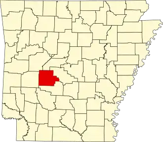
Garland County
| County in de Verenigde Staten | |||
|---|---|---|---|
| |||
| Situering | |||
| Staat | Arkansas | ||
| Coördinaten | 34°35'1"NB, 93°7'39"WL | ||
| Algemeen | |||
| Oppervlakte | 1.903 km² | ||
| - land | 1.754 km² | ||
| - water | 149 km² | ||
| Inwoners (2000) |
88.068 (50 inw./km²) | ||
| Overig | |||
| Zetel | Hot Springs | ||
| FIPS-code | 05051 | ||
| Opgericht | 1873 | ||
| Website | www | ||
| Foto's | |||

| |||
 Bevolkingspiramide Garland County | |||
| Statistieken volkstelling Garland County | |||
| |||
Garland County is een county in de Amerikaanse staat Arkansas.
De county heeft een landoppervlakte van 1.754 km² en telt 88.068 inwoners (volkstelling 2000). De hoofdplaats is Hot Springs.
Bevolkingsontwikkeling
| Jaar | Inwoners | % ± | |
|---|---|---|---|
| 1900 | 18.773 | — | |
| 1910 | 27.271 | 45,3% | |
| 1920 | 25.785 | −5,4% | |
| 1930 | 36.031 | 39,7% | |
| 1940 | 41.664 | 15,6% | |
| 1950 | 47.102 | 13,1% | |
| 1960 | 46.697 | −0,9% | |
| 1970 | 54.131 | 15,9% | |
| 1980 | 70.531 | 30,3% | |
| 1990 | 73.397 | 4,1% | |
| 2000 | 88.068 | 20,0% | |
| Bron: (en) Historical Decennial Census Population | |||