Garfield County (Colorado)
| County in de Verenigde Staten | |||
|---|---|---|---|

| |||
| Situering | |||
| Staat | Colorado | ||
| Coördinaten | 39°36'NB, 107°54'WL | ||
| Algemeen | |||
| Oppervlakte | 7.656 km² | ||
| - land | 7.633 km² | ||
| - water | 23 km² | ||
| Inwoners (2000) |
43.791 (6 inw./km²) | ||
| Overig | |||
| Zetel | Glenwood Springs | ||
| FIPS-code | 08045 | ||
| Website | www | ||
| Foto's | |||

| |||
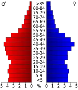 Bevolkingspiramide Garfield County | |||
| Statistieken volkstelling Garfield County | |||
| |||
Garfield County is een county in de Amerikaanse staat Colorado.
De county heeft een landoppervlakte van 7.633 km² en telt 43.791 inwoners (volkstelling 2000). De hoofdplaats is Glenwood Springs.
Bevolkingsontwikkeling
| Jaar | Inwoners | % ± | |
|---|---|---|---|
| 1900 | 5.835 | — | |
| 1910 | 10.144 | 73,8% | |
| 1920 | 9.304 | −8,3% | |
| 1930 | 9.975 | 7,2% | |
| 1940 | 10.560 | 5,9% | |
| 1950 | 11.625 | 10,1% | |
| 1960 | 12.017 | 3,4% | |
| 1970 | 14.821 | 23,3% | |
| 1980 | 22.514 | 51,9% | |
| 1990 | 29.974 | 33,1% | |
| 2000 | 43.791 | 46,1% | |
| Bron: (en) Historical Decennial Census Population | |||