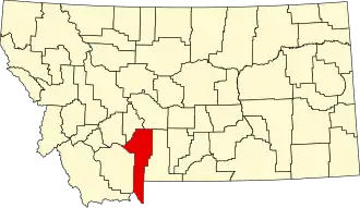
Gallatin County (Montana)
| County in de Verenigde Staten | |||
|---|---|---|---|
| |||
| Situering | |||
| Staat | Montana | ||
| Coördinaten | 45°33'36"NB, 111°10'12"WL | ||
| Algemeen | |||
| Oppervlakte | 6.816 km² | ||
| - land | 6.749 km² | ||
| - water | 67 km² | ||
| Inwoners (2000) |
67.831 (10 inw./km²) | ||
| Overig | |||
| Zetel | Bozeman | ||
| FIPS-code | 30031 | ||
| Opgericht | 1864 | ||
| Website | www | ||
| Foto's | |||

| |||
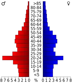 Bevolkingspiramide Gallatin County | |||
| Statistieken volkstelling Gallatin County | |||
| |||
Gallatin County is een county in de Amerikaanse staat Montana.
De county heeft een landoppervlakte van 6.749 km² en telt 67.831 inwoners (volkstelling 2000). De hoofdplaats is Bozeman.
Bevolkingsontwikkeling
| Jaar | Inwoners | % ± | |
|---|---|---|---|
| 1900 | 9.553 | — | |
| 1910 | 14.079 | 47,4% | |
| 1920 | 15.864 | 12,7% | |
| 1930 | 16.124 | 1,6% | |
| 1940 | 18.269 | 13,3% | |
| 1950 | 21.902 | 19,9% | |
| 1960 | 26.045 | 18,9% | |
| 1970 | 32.505 | 24,8% | |
| 1980 | 42.865 | 31,9% | |
| 1990 | 50.463 | 17,7% | |
| 2000 | 67.831 | 34,4% | |
| Bron: (en) Historical Decennial Census Population | |||
