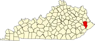
Floyd County (Kentucky)
| County in de Verenigde Staten | |||
|---|---|---|---|
| |||
| Situering | |||
| Staat | Kentucky | ||
| Coördinaten | 37°33'36"NB, 82°45'0"WL | ||
| Algemeen | |||
| Oppervlakte | 1.024 km² | ||
| - land | 1.021 km² | ||
| - water | 3 km² | ||
| Inwoners (2000) |
42.441 (42 inw./km²) | ||
| Overig | |||
| Zetel | Prestonsburg | ||
| FIPS-code | 21071 | ||
| Opgericht | 1799 | ||
| Website | www | ||
| Foto's | |||
%252C_Prestonsburg.jpg)
| |||
 Bevolkingspiramide Floyd County | |||
| Statistieken volkstelling Floyd County | |||
| |||
Floyd County is een county in de Amerikaanse staat Kentucky.
De county heeft een landoppervlakte van 1.021 km² en telt 42.441 inwoners (volkstelling 2000). De hoofdplaats is Prestonsburg.
Bevolkingsontwikkeling
| Jaar | Inwoners | % ± | |
|---|---|---|---|
| 1900 | 15.552 | — | |
| 1910 | 18.623 | 19,7% | |
| 1920 | 27.427 | 47,3% | |
| 1930 | 41.942 | 52,9% | |
| 1940 | 52.986 | 26,3% | |
| 1950 | 53.500 | 1,0% | |
| 1960 | 41.642 | −22,2% | |
| 1970 | 35.889 | −13,8% | |
| 1980 | 48.764 | 35,9% | |
| 1990 | 43.586 | −10,6% | |
| 2000 | 42.441 | −2,6% | |
| Bron: (en) Historical Decennial Census Population | |||