Fleming County
| County in de Verenigde Staten | |||
|---|---|---|---|
| |||
| Situering | |||
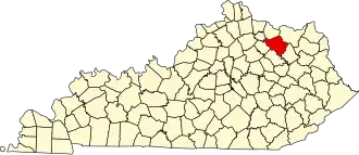
| Staat | Kentucky | ||
| Coördinaten | 38°22'12"NB, 83°41'24"WL | ||
| Algemeen | |||
| Oppervlakte | 911 km² | ||
| - land | 909 km² | ||
| - water | 2 km² | ||
| Inwoners (2000) |
13.792 (15 inw./km²) | ||
| Overig | |||
| Zetel | Flemingsburg | ||
| FIPS-code | 21069 | ||
| Opgericht | 1798 | ||
| Website | www | ||
| Foto's | |||

| |||
 Bevolkingspiramide Fleming County | |||
| Statistieken volkstelling Fleming County | |||
| |||
Fleming County is een county in de Amerikaanse staat Kentucky.
De county heeft een landoppervlakte van 909 km² en telt 13.792 inwoners (volkstelling 2000). De hoofdplaats is Flemingsburg.
Bevolkingsontwikkeling
| Jaar | Inwoners | % ± | |
|---|---|---|---|
| 1900 | 17.074 | — | |
| 1910 | 16.066 | −5,9% | |
| 1920 | 15.614 | −2,8% | |
| 1930 | 12.931 | −17,2% | |
| 1940 | 13.327 | 3,1% | |
| 1950 | 11.962 | −10,2% | |
| 1960 | 10.890 | −9,0% | |
| 1970 | 11.366 | 4,4% | |
| 1980 | 12.323 | 8,4% | |
| 1990 | 12.292 | −0,3% | |
| 2000 | 13.792 | 12,2% | |
| Bron: (en) Historical Decennial Census Population | |||