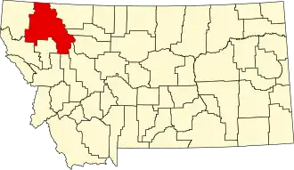
Flathead County
| County in de Verenigde Staten | |||
|---|---|---|---|
| |||
| Situering | |||
| Staat | Montana | ||
| Coördinaten | 48°17'24"NB, 114°1'12"WL | ||
| Algemeen | |||
| Oppervlakte | 13.615 km² | ||
| - land | 13.205 km² | ||
| - water | 410 km² | ||
| Inwoners (2000) |
74.471 (6 inw./km²) | ||
| Overig | |||
| Zetel | Kalispell | ||
| FIPS-code | 30029 | ||
| Opgericht | 1893 | ||
| Website | flathead | ||
| Foto's | |||

| |||
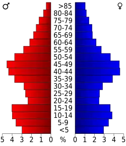 Bevolkingspiramide Flathead County | |||
| Statistieken volkstelling Flathead County | |||
| |||
Flathead County is een county in de Amerikaanse staat Montana.
De county heeft een landoppervlakte van 13.205 km² en telt 74.471 inwoners (volkstelling 2000). De hoofdplaats is Kalispell.
Bevolkingsontwikkeling
| Jaar | Inwoners | % ± | |
|---|---|---|---|
| 1900 | 9.375 | — | |
| 1910 | 18.785 | 100,4% | |
| 1920 | 21.705 | 15,5% | |
| 1930 | 19.200 | −11,5% | |
| 1940 | 24.271 | 26,4% | |
| 1950 | 31.495 | 29,8% | |
| 1960 | 32.965 | 4,7% | |
| 1970 | 39.460 | 19,7% | |
| 1980 | 51.966 | 31,7% | |
| 1990 | 59.218 | 14,0% | |
| 2000 | 74.471 | 25,8% | |
| Bron: (en) Historical Decennial Census Population | |||