Ellesmere Port and Neston
| District in Engeland | |||
|---|---|---|---|
| |||
| Situering | |||
| Land | Engeland | ||
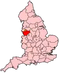
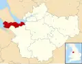
| County | Cheshire | ||
| Regio | North West England | ||
| Coördinaten | 53°16'34"NB, 2°58'8"WL | ||
| Algemeen | |||
| Oppervlakte | 88,4 km² | ||
| Inwoners (2001) |
81.672 (924 inw./km²) | ||
| Opgeheven | 1 april 2009 | ||
| ONS-code | 13UE | ||
| |||
Ellesmere Port and Neston was een Engels district in het graafschap Cheshire en telde 81.672 inwoners (2001). De oppervlakte bedraagt 88,4 km². In april 2009 werd het district opgeheven en ging op in de unitary authority Cheshire West and Chester.
Van de bevolking is 16,3% ouder dan 65 jaar. De werkloosheid bedraagt 3,2% van de beroepsbevolking (cijfers volkstelling 2001).
Plaatsen in district Ellesmere Port and Neston
Bronnen, noten en/of referenties