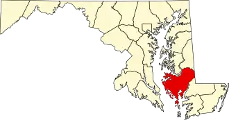
Dorchester County (Maryland)
| County in de Verenigde Staten | |||
|---|---|---|---|
| |||
| Situering | |||
| Staat | Maryland | ||
| Coördinaten | 38°25'12"NB, 76°4'48"WL | ||
| Algemeen | |||
| Oppervlakte | 2.546 km² | ||
| - land | 1.444 km² | ||
| - water | 1.102 km² | ||
| Inwoners (2000) |
30.674 (21 inw./km²) | ||
| Overig | |||
| Zetel | Cambridge | ||
| FIPS-code | 24019 | ||
| Opgericht | 1668 | ||
| Website | dorchestercountymd | ||
| Foto's | |||

| |||
 Bevolkingspiramide Dorchester County | |||
| Statistieken volkstelling Dorchester County | |||
| |||
Dorchester County is een county in de Amerikaanse staat Maryland.
De county heeft een landoppervlakte van 1.444 km² en telt 30.674 inwoners (volkstelling 2000). De hoofdplaats is Cambridge.
Bevolkingsontwikkeling
| Jaar | Inwoners | % ± | |
|---|---|---|---|
| 1900 | 27.962 | — | |
| 1910 | 28.669 | 2,5% | |
| 1920 | 27.895 | −2,7% | |
| 1930 | 26.813 | −3,9% | |
| 1940 | 28.006 | 4,4% | |
| 1950 | 27.815 | −0,7% | |
| 1960 | 29.666 | 6,7% | |
| 1970 | 29.405 | −0,9% | |
| 1980 | 30.623 | 4,1% | |
| 1990 | 30.236 | −1,3% | |
| 2000 | 30.674 | 1,4% | |
| Bron: (en) Historical Decennial Census Population | |||