Dartford (district)
| Niet-metropolitaans district in Engeland | |||
|---|---|---|---|
| |||
| Situering | |||
| Land | Engeland | ||
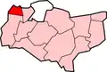
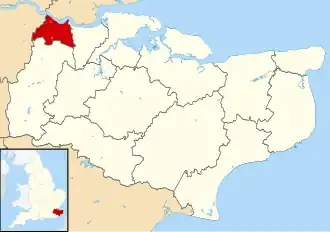
| County | Kent | ||
| Regio | South East England | ||
| Coördinaten | 51°27'NB, 0°16'OL | ||
| Algemeen | |||
| Oppervlakte | 72,7640[1] km² | ||
| Inwoners (2001) |
85.911 (1181 inw./km²) | ||
| Opgericht | 1 april 1974 | ||
| ONS-code | E07000107 | ||
| Website | www | ||
| Detailkaart | |||
| |||
| |||
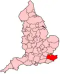
Dartford is een Engels district in het shire-graafschap (non-metropolitan county OF county) Kent en telt 85.911 inwoners. De oppervlakte bedraagt 73 km². Hoofdplaats is Dartford.
Van de bevolking is 14,4% ouder dan 65 jaar. De werkloosheid bedraagt 2,5% van de beroepsbevolking (cijfers volkstelling 2001).
Plaatsen in district Dartford
Civil parishes in district Dartford
Bean, Darenth, Longfield and New Barn, Southfleet, Stone, Sutton-at-Hone and Hawley, Swanscombe and Greenhithe, Wilmington.
Bronnen, noten en/of referenties
- ↑ Office for National Statistics → Download → SAM_for_Administrative_Areas_(2017).zip → SAM_LAD_DEC_2017_UK.xlsx. Gearchiveerd op 9 mei 2019.