Custer County (Colorado)
| County in de Verenigde Staten | |||
|---|---|---|---|
| |||
| Situering | |||
| Staat | Colorado | ||
| Coördinaten | 38°5'24"NB, 105°21'36"WL | ||
| Algemeen | |||
| Oppervlakte | 1.917 km² | ||
| - land | 1.914 km² | ||
| - water | 3 km² | ||
| Inwoners (2000) |
3.503 (2 inw./km²) | ||
| Overig | |||
| Zetel | Westcliffe | ||
| FIPS-code | 08027 | ||
| Opgericht | 1877 | ||
| Website | custercountygov | ||
| Foto's | |||
| |||
 Bevolkingspiramide Custer County | |||
| Statistieken volkstelling Custer County | |||
| |||
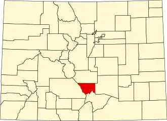
Custer County is een county in de Amerikaanse staat Colorado.
De county heeft een landoppervlakte van 1.914 km² en telt 3.503 inwoners (volkstelling 2000). De hoofdplaats is Westcliffe.
Bevolkingsontwikkeling
| Jaar | Inwoners | % ± | |
|---|---|---|---|
| 1900 | 2.937 | — | |
| 1910 | 1.947 | −33,7% | |
| 1920 | 2.172 | 11,6% | |
| 1930 | 2.124 | −2,2% | |
| 1940 | 2.270 | 6,9% | |
| 1950 | 1.573 | −30,7% | |
| 1960 | 1.305 | −17,0% | |
| 1970 | 1.120 | −14,2% | |
| 1980 | 1.528 | 36,4% | |
| 1990 | 1.926 | 26,0% | |
| 2000 | 3.503 | 81,9% | |
| Bron: (en) Historical Decennial Census Population | |||