Crawford County (Missouri)
| County in de Verenigde Staten | |||
|---|---|---|---|
| |||
| Situering | |||
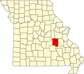
| Staat | Missouri | ||
| Coördinaten | 37°58'48"NB, 91°18'0"WL | ||
| Algemeen | |||
| Oppervlakte | 1.926 km² | ||
| - land | 1.923 km² | ||
| - water | 3 km² | ||
| Inwoners (2000) |
22.804 (12 inw./km²) | ||
| Overig | |||
| Zetel | Steelville | ||
| FIPS-code | 29055 | ||
| Opgericht | 1829 | ||
| Website | crawfordcountymo | ||
| Foto's | |||

| |||
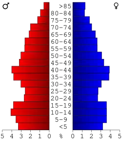 Bevolkingspiramide Crawford County | |||
| Statistieken volkstelling Crawford County | |||
| |||
Crawford County is een county in de Amerikaanse staat Missouri.
De county heeft een landoppervlakte van 1.923 km² en telt 22.804 inwoners (volkstelling 2000). De hoofdplaats is Steelville.
Bevolkingsontwikkeling
| Jaar | Inwoners | % ± | |
|---|---|---|---|
| 1900 | 12.959 | — | |
| 1910 | 13.576 | 4,8% | |
| 1920 | 12.355 | −9,0% | |
| 1930 | 11.287 | −8,6% | |
| 1940 | 12.693 | 12,5% | |
| 1950 | 11.615 | −8,5% | |
| 1960 | 12.647 | 8,9% | |
| 1970 | 14.828 | 17,2% | |
| 1980 | 18.300 | 23,4% | |
| 1990 | 19.173 | 4,8% | |
| 2000 | 22.804 | 18,9% | |
| Bron: (en) Historical Decennial Census Population | |||