Crawford County (Michigan)
| County in de Verenigde Staten | |||
|---|---|---|---|

| |||
| Situering | |||
| Staat | Michigan | ||
| Coördinaten | 44°40'48"NB, 84°36'36"WL | ||
| Algemeen | |||
| Oppervlakte | 1.460 km² | ||
| - land | 1.446 km² | ||
| - water | 14 km² | ||
| Inwoners (2000) |
14.273 (10 inw./km²) | ||
| Overig | |||
| Zetel | Grayling | ||
| FIPS-code | 26039 | ||
| Opgericht | 1840 | ||
| Website | www | ||
| Foto's | |||
.jpg)
| |||
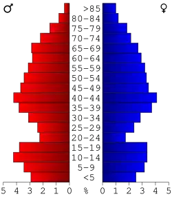 Bevolkingspiramide Crawford County | |||
| Statistieken volkstelling Crawford County | |||
| |||
Crawford County is een county in de Amerikaanse staat Michigan.
De county heeft een landoppervlakte van 1.446 km² en telt 14.273 inwoners (volkstelling 2000). De hoofdplaats is Grayling.
Bevolkingsontwikkeling
| Jaar | Inwoners | % ± | |
|---|---|---|---|
| 1900 | 2.943 | — | |
| 1910 | 3.934 | 33,7% | |
| 1920 | 4.049 | 2,9% | |
| 1930 | 3.097 | −23,5% | |
| 1940 | 3.765 | 21,6% | |
| 1950 | 4.151 | 10,3% | |
| 1960 | 4.971 | 19,8% | |
| 1970 | 6.482 | 30,4% | |
| 1980 | 9.465 | 46,0% | |
| 1990 | 12.260 | 29,5% | |
| 2000 | 14.273 | 16,4% | |
| Bron: (en) Historical Decennial Census Population | |||
Foto's
-
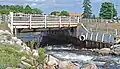 brug
brug