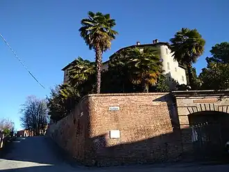
Cossombrato
| Gemeente in Italië | |||
|---|---|---|---|
 | |||
 | |||
| Situering | |||
| Regio | Piëmont (PMN) | ||
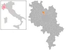
| Provincie | Asti (AT) | ||
| Coördinaten | 45° 0′ NB, 8° 8′ OL | ||
| Algemeen | |||
| Oppervlakte | 5,3 km² | ||
| Inwoners (1 januari 2023) |
517[1] (93 inw./km²) | ||
| Overig | |||
| Postcode | 14020 | ||
| Netnummer | 0141 | ||
| Beschermheilige | Stefanus | ||
| ISTAT-code | 005049 | ||
| Website | http://www.comune.cossombrato.at.it | ||
| Detailkaart | |||
| |||
| Locatie van Cossombrato in Asti (AT) | |||
 | |||
| Foto's | |||
| |||
| |||
Cossombrato is een gemeente in de Italiaanse provincie Asti (regio Piëmont) en telt 493 inwoners (31-12-2004). De oppervlakte bedraagt 5,3 km², de bevolkingsdichtheid is 93 inwoners per km².
Demografie
Cossombrato telt ongeveer 229 huishoudens. Het aantal inwoners steeg in de periode 1991-2001 met 14,6% volgens cijfers uit de tienjaarlijkse volkstellingen van ISTAT.
| Jaar | Inwoneraantal |
|---|---|
| 1991 | 426 |
| 2001 | 488 |
Geografie
Cossombrato grenst aan de volgende gemeenten: Asti, Castell'Alfero, Chiusano d'Asti, Corsione, Montechiaro d'Asti, Villa San Secondo.
Bronnen, noten en/of referenties