Coosa County
| County in de Verenigde Staten | |||
|---|---|---|---|
| |||
| Situering | |||
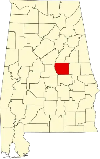
| Staat | Alabama | ||
| Coördinaten | 32°56'11"NB, 86°14'47"WL | ||
| Algemeen | |||
| Oppervlakte | 1.726 km² | ||
| - land | 1.690 km² | ||
| - water | 36 km² | ||
| Inwoners (2000) |
12.202 (7 inw./km²) | ||
| Overig | |||
| Zetel | Rockford | ||
| FIPS-code | 01037 | ||
| Opgericht | 1832 | ||
| Website | www | ||
| Foto's | |||

| |||
 Bevolkingspiramide Coosa County | |||
| Statistieken volkstelling Coosa County | |||
| |||
Coosa County is een county in de Amerikaanse staat Alabama.
De county heeft een landoppervlakte van 1.690 km² en telt 12.202 inwoners (volkstelling 2000). De hoofdplaats is Rockford.
Bevolkingsontwikkeling
| Jaar | Inwoners | % ± | |
|---|---|---|---|
| 1900 | 16.144 | — | |
| 1910 | 16.634 | 3,0% | |
| 1920 | 14.839 | −10,8% | |
| 1930 | 12.460 | −16,0% | |
| 1940 | 13.460 | 8,0% | |
| 1950 | 11.766 | −12,6% | |
| 1960 | 10.726 | −8,8% | |
| 1970 | 10.662 | −0,6% | |
| 1980 | 11.377 | 6,7% | |
| 1990 | 11.063 | −2,8% | |
| 2000 | 12.202 | 10,3% | |
| Bron: (en) Historical Decennial Census Population | |||