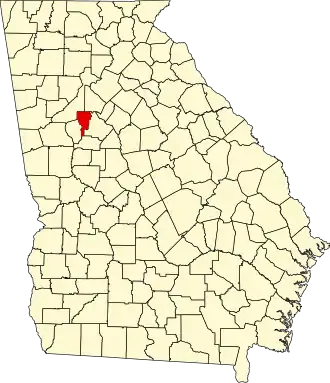
Clayton County (Georgia)
| County in de Verenigde Staten | |||
|---|---|---|---|
| |||
| Situering | |||
| Staat | Georgia | ||
| Coördinaten | 33°32'24"NB, 84°21'36"WL | ||
| Algemeen | |||
| Oppervlakte | 373 km² | ||
| - land | 369 km² | ||
| - water | 4 km² | ||
| Inwoners (2000) |
236.517 (641 inw./km²) | ||
| Overig | |||
| Zetel | Jonesboro | ||
| FIPS-code | 13063 | ||
| Opgericht | 1858 | ||
| Website | www | ||
| Foto's | |||

| |||
 Bevolkingspiramide Clayton County | |||
| Statistieken volkstelling Clayton County | |||
| |||
Clayton County is een county in de Amerikaanse staat Georgia.
De county heeft een landoppervlakte van 369 km² en telt 236.517 inwoners (volkstelling 2000). De hoofdplaats is Jonesboro.
Bevolkingsontwikkeling
| Jaar | Inwoners | % ± | |
|---|---|---|---|
| 1900 | 9.598 | — | |
| 1910 | 10.453 | 8,9% | |
| 1920 | 11.159 | 6,8% | |
| 1930 | 10.260 | −8,1% | |
| 1940 | 11.655 | 13,6% | |
| 1950 | 22.872 | 96,2% | |
| 1960 | 46.365 | 102,7% | |
| 1970 | 98.043 | 111,5% | |
| 1980 | 150.357 | 53,4% | |
| 1990 | 182.052 | 21,1% | |
| 2000 | 236.517 | 29,9% | |
| Bron: (en) Historical Decennial Census Population | |||