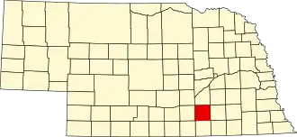
Clay County (Nebraska)
| County in de Verenigde Staten | |||
|---|---|---|---|
| |||
| Situering | |||
| Staat | Nebraska | ||
| Coördinaten | 40°31'12"NB, 98°3'0"WL | ||
| Algemeen | |||
| Oppervlakte | 1.485 km² | ||
| - land | 1.484 km² | ||
| - water | 1 km² | ||
| Inwoners (2000) |
7.039 (5 inw./km²) | ||
| Overig | |||
| Zetel | Clay Center | ||
| FIPS-code | 31035 | ||
| Opgericht | 1855 | ||
| Website | www | ||
| Foto's | |||
_6.jpg)
| |||
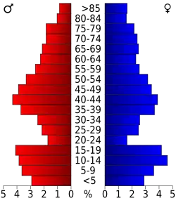 Bevolkingspiramide Clay County | |||
| Statistieken volkstelling Clay County | |||
| |||
Clay County is een county in de Amerikaanse staat Nebraska.
De county heeft een landoppervlakte van 1.484 km² en telt 7.039 inwoners (volkstelling 2000). De hoofdplaats is Clay Center.
Bevolkingsontwikkeling
| Jaar | Inwoners | % ± | |
|---|---|---|---|
| 1900 | 15.735 | — | |
| 1910 | 15.729 | −0,0% | |
| 1920 | 14.486 | −7,9% | |
| 1930 | 13.571 | −6,3% | |
| 1940 | 10.445 | −23,0% | |
| 1950 | 8.700 | −16,7% | |
| 1960 | 8.717 | 0,2% | |
| 1970 | 8.266 | −5,2% | |
| 1980 | 8.106 | −1,9% | |
| 1990 | 7.123 | −12,1% | |
| 2000 | 7.039 | −1,2% | |
| Bron: (en) Historical Decennial Census Population | |||