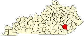
Clay County (Kentucky)
| County in de Verenigde Staten | |||
|---|---|---|---|
| |||
| Situering | |||
| Staat | Kentucky | ||
| Coördinaten | 37°9'36"NB, 83°42'36"WL | ||
| Algemeen | |||
| Oppervlakte | 1.220 km² | ||
| - land | 1.220 km² | ||
| - water | 0 km² | ||
| Inwoners (2000) |
24.556 (20 inw./km²) | ||
| Overig | |||
| Zetel | Manchester | ||
| FIPS-code | 21051 | ||
| Opgericht | 1806 | ||
| Website | claycounty | ||
| Foto's | |||

| |||
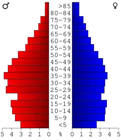 Bevolkingspiramide Clay County | |||
| Statistieken volkstelling Clay County | |||
| |||
Clay County is een county in de Amerikaanse staat Kentucky.
De county heeft een landoppervlakte van 1.220 km² en telt 24.556 inwoners (volkstelling 2000). De hoofdplaats is Manchester.
Bevolkingsontwikkeling
| Jaar | Inwoners | % ± | |
|---|---|---|---|
| 1900 | 15.364 | — | |
| 1910 | 17.789 | 15,8% | |
| 1920 | 19.795 | 11,3% | |
| 1930 | 18.526 | −6,4% | |
| 1940 | 23.901 | 29,0% | |
| 1950 | 23.116 | −3,3% | |
| 1960 | 20.748 | −10,2% | |
| 1970 | 18.481 | −10,9% | |
| 1980 | 22.752 | 23,1% | |
| 1990 | 21.746 | −4,4% | |
| 2000 | 24.556 | 12,9% | |
| Bron: (en) Historical Decennial Census Population | |||
Externe link