St Albans (district)
| Niet-metropolitaans district in Engeland | |||
|---|---|---|---|
 | |||
| |||
| Situering | |||
| Land | Engeland | ||
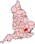
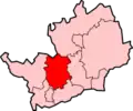
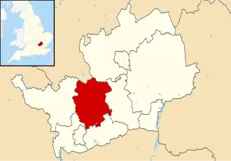
| County | Hertfordshire | ||
| Regio | East of England | ||
| Coördinaten | 51°47'NB, 0°20'WL | ||
| Algemeen | |||
| Oppervlakte | 161,2058[1] km² | ||
| Inwoners (2018[2]) |
147.373 (914 inw./km²) | ||
| ONS-code | E07000240 | ||
| Website | www | ||
| Detailkaart | |||
| |||
| |||
St Albans is een district met de officiële titel van city, in het shire-graafschap (non-metropolitan county OF county) Hertfordshire en telt 147.000 inwoners. De oppervlakte bedraagt 161 km².
Van de bevolking is 14,9% ouder dan 65 jaar. De werkloosheid bedraagt 1,7% van de beroepsbevolking (cijfers volkstelling 2001).
De stad St Albans telt ongeveer 58.000 inwoners.
Plaatsen in district St Albans
Civil parishes in district St Albans
Colney Heath, Harpenden, Harpenden Rural, London Colney, Redbourn, Sandridge, St Michael, St Stephen, Wheathampstead.
Bronnen, noten en/of referenties
- ↑ Office for National Statistics → Download → SAM_for_Administrative_Areas_(2018).zip → SAM_LAD_DEC_2018_UK.xlsx.
- ↑ https://www.ons.gov.uk/file?uri=/peoplepopulationandcommunity/populationandmigration/populationestimates/datasets/populationestimatesforukenglandandwalesscotlandandnorthernireland/mid20182019laboundaries/ukmidyearestimates20182019ladcodes.xls Schatting Office for National Statistics: knop MYE5 → kolom Estimated Population mid-2018]