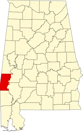
Choctaw County (Alabama)
| County in de Verenigde Staten | |||
|---|---|---|---|
| |||
| Situering | |||
| Staat | Alabama | ||
| Coördinaten | 32°1'13"NB, 88°15'47"WL | ||
| Algemeen | |||
| Oppervlakte | 2.385 km² | ||
| - land | 2.366 km² | ||
| - water | 19 km² | ||
| Inwoners (2000) |
15.922 (7 inw./km²) | ||
| Overig | |||
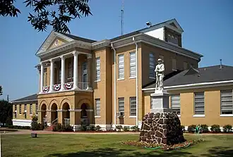
| Zetel | Butler | ||
| FIPS-code | 01023 | ||
| Opgericht | 1847 | ||
| Website | www | ||
| Foto's | |||
| |||
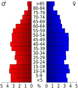 Bevolkingspiramide Choctaw County | |||
| Statistieken volkstelling Choctaw County | |||
| |||
Choctaw County is een county in de Amerikaanse staat Alabama.
De county heeft een landoppervlakte van 2.366 km² en telt 15.922 inwoners (volkstelling 2000). De hoofdplaats is Butler.
Bevolkingsontwikkeling
| Jaar | Inwoners | % ± | |
|---|---|---|---|
| 1900 | 18.136 | — | |
| 1910 | 18.483 | 1,9% | |
| 1920 | 20.753 | 12,3% | |
| 1930 | 20.513 | −1,2% | |
| 1940 | 20.195 | −1,6% | |
| 1950 | 19.152 | −5,2% | |
| 1960 | 17.870 | −6,7% | |
| 1970 | 16.589 | −7,2% | |
| 1980 | 16.839 | 1,5% | |
| 1990 | 16.018 | −4,9% | |
| 2000 | 15.922 | −0,6% | |
| Bron: (en) Historical Decennial Census Population | |||