Chariton County
| County in de Verenigde Staten | |||
|---|---|---|---|
| |||
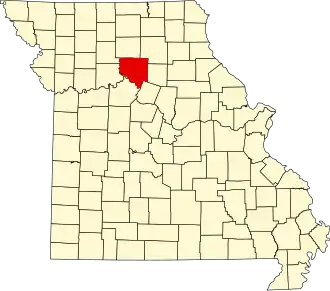
| Situering | |||
| Staat | Missouri | ||
| Coördinaten | 39°31'12"NB, 92°57'36"WL | ||
| Algemeen | |||
| Oppervlakte | 1.990 km² | ||
| - land | 1.958 km² | ||
| - water | 32 km² | ||
| Inwoners (2000) |
8.438 (4 inw./km²) | ||
| Overig | |||
| Zetel | Keytesville | ||
| FIPS-code | 29041 | ||
| Opgericht | 1820 | ||
| Website | www | ||
| Foto's | |||

| |||
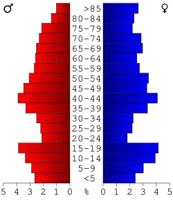 Bevolkingspiramide Chariton County | |||
| Statistieken volkstelling Chariton County | |||
| |||
Chariton County is een county in de Amerikaanse staat Missouri.
De county heeft een landoppervlakte van 1.958 km² en telt 8.438 inwoners (volkstelling 2000). De hoofdplaats is Keytesville.
Bevolkingsontwikkeling
| Jaar | Inwoners | % ± | |
|---|---|---|---|
| 1900 | 26.826 | — | |
| 1910 | 23.503 | −12,4% | |
| 1920 | 21.769 | −7,4% | |
| 1930 | 19.588 | −10,0% | |
| 1940 | 18.084 | −7,7% | |
| 1950 | 14.944 | −17,4% | |
| 1960 | 12.720 | −14,9% | |
| 1970 | 11.084 | −12,9% | |
| 1980 | 10.489 | −5,4% | |
| 1990 | 9.202 | −12,3% | |
| 2000 | 8.438 | −8,3% | |
| Bron: (en) Historical Decennial Census Population | |||