Cecil County
| County in de Verenigde Staten | |||
|---|---|---|---|
| |||
| Situering | |||
| Staat | Maryland | ||
| Coördinaten | 39°34'12"NB, 75°57'0"WL | ||
| Algemeen | |||
| Oppervlakte | 1.083 km² | ||
| - land | 902 km² | ||
| - water | 181 km² | ||
| Inwoners (2000) |
85.951 (95 inw./km²) | ||
| Overig | |||
| Zetel | Elkton | ||
| FIPS-code | 24015 | ||
| Opgericht | 1674 | ||
| Website | www | ||
| Foto's | |||
.jpg)
| |||
 Bevolkingspiramide Cecil County | |||
| Statistieken volkstelling Cecil County | |||
| |||
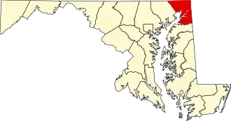
Cecil County is een county in de Amerikaanse staat Maryland.
De county heeft een landoppervlakte van 902 km² en telt 85.951 inwoners (volkstelling 2000). De hoofdplaats is Elkton.
Bevolkingsontwikkeling
| Jaar | Inwoners | % ± | |
|---|---|---|---|
| 1900 | 24.662 | — | |
| 1910 | 23.759 | −3,7% | |
| 1920 | 23.612 | −0,6% | |
| 1930 | 25.827 | 9,4% | |
| 1940 | 26.407 | 2,2% | |
| 1950 | 33.356 | 26,3% | |
| 1960 | 48.408 | 45,1% | |
| 1970 | 53.291 | 10,1% | |
| 1980 | 60.430 | 13,4% | |
| 1990 | 71.347 | 18,1% | |
| 2000 | 85.951 | 20,5% | |
| Bron: (en) Historical Decennial Census Population | |||