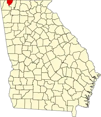
Catoosa County
| County in de Verenigde Staten | |||
|---|---|---|---|
| |||
| Situering | |||
| Staat | Georgia | ||
| Coördinaten | 34°54'0"NB, 85°8'24"WL | ||
| Algemeen | |||
| Oppervlakte | 421 km² | ||
| - land | 420 km² | ||
| - water | 1 km² | ||
| Inwoners (2000) |
53.282 (127 inw./km²) | ||
| Overig | |||
| Zetel | Ringgold | ||
| FIPS-code | 13047 | ||
| Opgericht | 1853 | ||
| Website | www | ||
| Foto's | |||

| |||
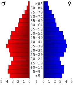 Bevolkingspiramide Catoosa County | |||
| Statistieken volkstelling Catoosa County | |||
| |||
Catoosa County is een county in de Amerikaanse staat Georgia.
De county heeft een landoppervlakte van 420 km² en telt 53.282 inwoners (volkstelling 2000). De hoofdplaats is Ringgold.
Bevolkingsontwikkeling
| Jaar | Inwoners | % ± | |
|---|---|---|---|
| 1900 | 5.823 | — | |
| 1910 | 7.184 | 23,4% | |
| 1920 | 6.677 | −7,1% | |
| 1930 | 9.421 | 41,1% | |
| 1940 | 12.199 | 29,5% | |
| 1950 | 15.146 | 24,2% | |
| 1960 | 21.101 | 39,3% | |
| 1970 | 28.271 | 34,0% | |
| 1980 | 36.991 | 30,8% | |
| 1990 | 42.464 | 14,8% | |
| 2000 | 53.282 | 25,5% | |
| Bron: (en) Historical Decennial Census Population | |||
Foto's
-
Rechtbank
Zie de categorie Catoosa County, Georgia van Wikimedia Commons voor mediabestanden over dit onderwerp.