Castanheira (Mato Grosso)
| Gemeente in Brazilië | |||
|---|---|---|---|
 | |||
| Situering | |||
| Regio | Centraal-West | ||
| Staat | Mato Grosso | ||
| Mesoregio | Norte Mato-Grossense | ||
| Microregio | Aripuanã | ||
| Coördinaten | 11° 8′ ZB, 58° 36′ WL | ||
| Algemeen | |||
| Oppervlakte | 3.948,861 km² | ||
| Inwoners (2009) |
8.059 (1,8 inw./km²) | ||
| Hoogte | 400 m | ||
| Gemeentenummer | 5102850 | ||
| Burgemeester | Dega | ||
| Overig | |||
| Tijdzone | UTC−4 | ||
| HDI | 0,73 | ||
| Website | castanheira.mt.gov.br | ||
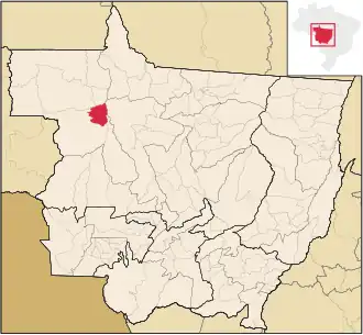
| Detailkaart | |||
| |||
| Locatie van Castanheira in de staat Mato Grosso | |||
| |||
Castanheira is een gemeente in de Braziliaanse deelstaat Mato Grosso. De gemeente telt 8.059 inwoners (schatting 2009).
Bronnen, noten en/of referenties