Carter County (Missouri)
| County in de Verenigde Staten | |||
|---|---|---|---|
| |||
| Situering | |||
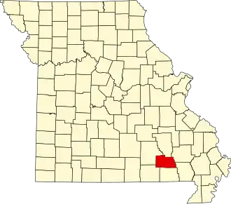
| Staat | Missouri | ||
| Coördinaten | 36°56'24"NB, 90°58'12"WL | ||
| Algemeen | |||
| Oppervlakte | 1.319 km² | ||
| - land | 1.315 km² | ||
| - water | 4 km² | ||
| Inwoners (2000) |
5.941 (5 inw./km²) | ||
| Overig | |||
| Zetel | Van Buren | ||
| FIPS-code | 29035 | ||
| Opgericht | 1859 | ||
| Website | www | ||
| Foto's | |||

| |||
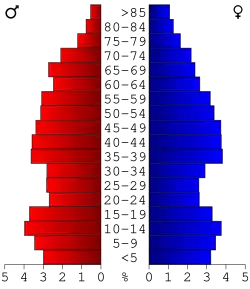 Bevolkingspiramide Carter County | |||
| Statistieken volkstelling Carter County | |||
| |||
Carter County is een county in de Amerikaanse staat Missouri.
De county heeft een landoppervlakte van 1.315 km² en telt 5.941 inwoners (volkstelling 2000). De hoofdplaats is Van Buren.
Bevolkingsontwikkeling
| Jaar | Inwoners | % ± | |
|---|---|---|---|
| 1900 | 6.706 | — | |
| 1910 | 5.504 | −17,9% | |
| 1920 | 7.482 | 35,9% | |
| 1930 | 5.503 | −26,5% | |
| 1940 | 6.226 | 13,1% | |
| 1950 | 4.777 | −23,3% | |
| 1960 | 3.973 | −16,8% | |
| 1970 | 3.878 | −2,4% | |
| 1980 | 5.428 | 40,0% | |
| 1990 | 5.515 | 1,6% | |
| 2000 | 5.941 | 7,7% | |
| Bron: (en) Historical Decennial Census Population | |||