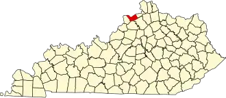
Carroll County (Kentucky)
| County in de Verenigde Staten | |||
|---|---|---|---|
| |||
| Situering | |||
| Staat | Kentucky | ||
| Coördinaten | 38°40'12"NB, 85°7'48"WL | ||
| Algemeen | |||
| Oppervlakte | 356 km² | ||
| - land | 337 km² | ||
| - water | 19 km² | ||
| Inwoners (2000) |
10.155 (30 inw./km²) | ||
| Overig | |||
| Zetel | Carrollton | ||
| FIPS-code | 21041 | ||
| Opgericht | 1838 | ||
| Website | www | ||
| Foto's | |||

| |||
 Bevolkingspiramide Carroll County | |||
| Statistieken volkstelling Carroll County | |||
| |||
Carroll County is een county in de Amerikaanse staat Kentucky.
De county heeft een landoppervlakte van 337 km² en telt 10.155 inwoners (volkstelling 2000). De hoofdplaats is Carrollton.
Bevolkingsontwikkeling
| Jaar | Inwoners | % ± | |
|---|---|---|---|
| 1900 | 9.825 | — | |
| 1910 | 8.110 | −17,5% | |
| 1920 | 8.346 | 2,9% | |
| 1930 | 8.155 | −2,3% | |
| 1940 | 8.657 | 6,2% | |
| 1950 | 8.517 | −1,6% | |
| 1960 | 7.978 | −6,3% | |
| 1970 | 8.523 | 6,8% | |
| 1980 | 9.270 | 8,8% | |
| 1990 | 9.292 | 0,2% | |
| 2000 | 10.155 | 9,3% | |
| Bron: (en) Historical Decennial Census Population | |||