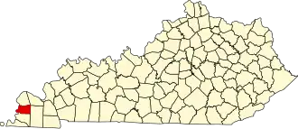
Carlisle County
| County in de Verenigde Staten | |||
|---|---|---|---|
| |||
| Situering | |||
| Staat | Kentucky | ||
| Coördinaten | 36°51'0"NB, 88°58'48"WL | ||
| Algemeen | |||
| Oppervlakte | 516 km² | ||
| - land | 499 km² | ||
| - water | 17 km² | ||
| Inwoners (2000) |
5.351 (11 inw./km²) | ||
| Overig | |||
| Zetel | Bardwell | ||
| FIPS-code | 21039 | ||
| Opgericht | 1886 | ||
| Website | carlislecounty | ||
| Foto's | |||

| |||
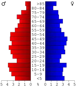 Bevolkingspiramide Carlisle County | |||
| Statistieken volkstelling Carlisle County | |||
| |||
Carlisle County is een county in de Amerikaanse staat Kentucky.
De county heeft een landoppervlakte van 499 km² en telt 5.351 inwoners (volkstelling 2000). De hoofdplaats is Bardwell.
Bevolkingsontwikkeling
| Jaar | Inwoners | % ± | |
|---|---|---|---|
| 1900 | 10.195 | — | |
| 1910 | 9.048 | −11,3% | |
| 1920 | 8.231 | −9,0% | |
| 1930 | 7.363 | −10,5% | |
| 1940 | 7.650 | 3,9% | |
| 1950 | 6.206 | −18,9% | |
| 1960 | 5.608 | −9,6% | |
| 1970 | 5.354 | −4,5% | |
| 1980 | 5.487 | 2,5% | |
| 1990 | 5.238 | −4,5% | |
| 2000 | 5.351 | 2,2% | |
| Bron: (en) Historical Decennial Census Population | |||