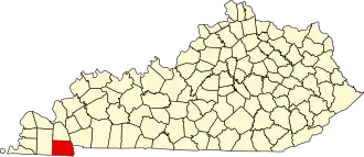
Calloway County
| County in de Verenigde Staten | |||
|---|---|---|---|
| |||
| Situering | |||
| Staat | Kentucky | ||
| Coördinaten | 36°37'12"NB, 88°16'12"WL | ||
| Algemeen | |||
| Oppervlakte | 1.064 km² | ||
| - land | 1.000 km² | ||
| - water | 64 km² | ||
| Inwoners (2000) |
34.177 (34 inw./km²) | ||
| Overig | |||
| Zetel | Murray | ||
| FIPS-code | 21035 | ||
| Opgericht | 1821 | ||
| Website | www | ||
| Foto's | |||

| |||
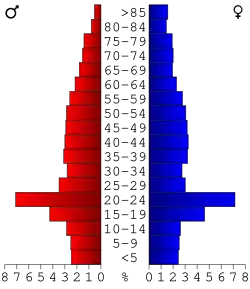 Bevolkingspiramide Calloway County | |||
| Statistieken volkstelling Calloway County | |||
| |||
Calloway County is een county in de Amerikaanse staat Kentucky.
De county heeft een landoppervlakte van 1.000 km² en telt 34.177 inwoners (volkstelling 2000). De hoofdplaats is Murray.
Bevolkingsontwikkeling
| Jaar | Inwoners | % ± | |
|---|---|---|---|
| 1900 | 17.633 | — | |
| 1910 | 19.867 | 12,7% | |
| 1920 | 20.802 | 4,7% | |
| 1930 | 17.662 | −15,1% | |
| 1940 | 19.041 | 7,8% | |
| 1950 | 20.147 | 5,8% | |
| 1960 | 20.972 | 4,1% | |
| 1970 | 27.692 | 32,0% | |
| 1980 | 30.031 | 8,4% | |
| 1990 | 30.735 | 2,3% | |
| 2000 | 34.177 | 11,2% | |
| Bron: (en) Historical Decennial Census Population | |||
Foto's
-
rechtbank