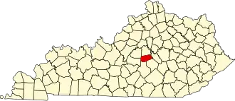
Boyle County
| County in de Verenigde Staten | |||
|---|---|---|---|
| |||
| Situering | |||
| Staat | Kentucky | ||
| Coördinaten | 37°37'12"NB, 84°52'12"WL | ||
| Algemeen | |||
| Oppervlakte | 474 km² | ||
| - land | 471 km² | ||
| - water | 3 km² | ||
| Inwoners (2000) |
27.697 (59 inw./km²) | ||
| Overig | |||
| Zetel | Danville | ||
| FIPS-code | 21021 | ||
| Opgericht | 1842 | ||
| Website | www | ||
| Foto's | |||

| |||
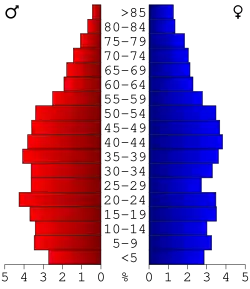 Bevolkingspiramide Boyle County | |||
| Statistieken volkstelling Boyle County | |||
| |||
Boyle County is een county in de Amerikaanse staat Kentucky.
De county heeft een landoppervlakte van 471 km² en telt 27.697 inwoners (volkstelling 2000). De hoofdplaats is Danville.
Bevolkingsontwikkeling
| Jaar | Inwoners | % ± | |
|---|---|---|---|
| 1900 | 13.817 | — | |
| 1910 | 14.668 | 6,2% | |
| 1920 | 14.998 | 2,2% | |
| 1930 | 16.282 | 8,6% | |
| 1940 | 17.075 | 4,9% | |
| 1950 | 20.532 | 20,2% | |
| 1960 | 21.257 | 3,5% | |
| 1970 | 21.090 | −0,8% | |
| 1980 | 25.066 | 18,9% | |
| 1990 | 25.641 | 2,3% | |
| 2000 | 27.697 | 8,0% | |
| Bron: (en) Historical Decennial Census Population | |||