Boulder County
| County in de Verenigde Staten | |||
|---|---|---|---|
| |||
| Situering | |||
| Staat | Colorado | ||
| Coördinaten | 40°5'24"NB, 105°21'36"WL | ||
| Algemeen | |||
| Oppervlakte | 1.946 km² | ||
| - land | 1.923 km² | ||
| - water | 23 km² | ||
| Inwoners (2000) |
291.288 (151 inw./km²) | ||
| Overig | |||
| Zetel | Boulder | ||
| FIPS-code | 08013 | ||
| Opgericht | 1861 | ||
| Website | www | ||
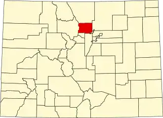
| Detailkaart | |||
| |||
| Overzichtskaart van Boulder County | |||
| Foto's | |||
.jpg)
| |||
 Bevolkingspiramide Boulder County | |||
| Statistieken volkstelling Boulder County | |||
| |||
Boulder County is een county in de Amerikaanse staat Colorado.
De county heeft een landoppervlakte van 1.923 km² en telt 291.288 inwoners (volkstelling 2000). De hoofdplaats is Boulder.
Bevolkingsontwikkeling
| Jaar | Inwoners | % ± | |
|---|---|---|---|
| 1900 | 21.544 | — | |
| 1910 | 30.330 | 40,8% | |
| 1920 | 31.861 | 5,0% | |
| 1930 | 32.456 | 1,9% | |
| 1940 | 37.438 | 15,4% | |
| 1950 | 48.296 | 29,0% | |
| 1960 | 74.254 | 53,7% | |
| 1970 | 131.889 | 77,6% | |
| 1980 | 189.625 | 43,8% | |
| 1990 | 225.339 | 18,8% | |
| 2000 | 291.288 | 29,3% | |
| Bron: (en) Historical Decennial Census Population | |||