Blaenau Gwent
| Unitaire autoriteit in Wales | |||
|---|---|---|---|
 | |||
| |||
| Coördinaten | 51°46'33"NB, 3°11'47"WL | ||
| Algemeen | |||
| Oppervlakte | 108,7279[1] km² | ||
| Inwoners | 69713 (2018)[2] (641 inw./km²) | ||
| Bestuurlijke status | county borough | ||
| Welsh sprekend | 13,3% | ||
| Overig | |||
| ISO 3166-2 | GB-BGW | ||
| ONS-code | W06000019 | ||
| Officiële website | blaenau-gwent.gov.uk | ||
| Website | Officiële website | ||
| Foto's | |||
.jpg)
| |||
| |||
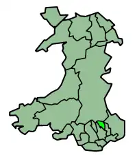
Blaenau Gwent is een unitaire autoriteit in het zuiden van Wales, gelegen in het ceremoniële behouden graafschap Gwent en het historische graafschap Monmouthshire. De county borough heeft 70.000 inwoners.
Plaatsen
- Abertillery
- Brynmawr
- Ebbw Vale (hoofdstad)
- Tredegar
Bronnen, noten en/of referenties