Black Bourton
| Civil parish in Engeland | |||
|---|---|---|---|
 | |||
| Situering | |||
| Regio | South East England | ||
| Graafschap | Oxfordshire | ||
| District | West Oxfordshire | ||
| Coördinaten | 51° 44' NB, 1° 35' WL | ||
| Algemeen | |||
| Oppervlakte | 5,8726 km² | ||
| Inwoners (2011) |
266 (45 inw./km²) | ||
| Overig | |||
| Postcode(s) | OX18 | ||
| Netnummer(s) | 01993 | ||
| Grid code | SP2803 | ||
| ONS-code | E04008261 | ||
| Website | www | ||
| Foto's | |||
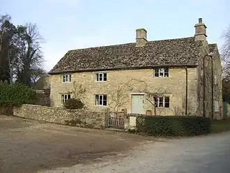
| |||
| The Old Inn | |||
| |||
Black Bourton is een civil parish in het bestuurlijke gebied West Oxfordshire, in het Engelse graafschap Oxfordshire met 266 inwoners.
Bronnen, noten en/of referenties
Geplaatst op:
5-8-2010
5-8-2010
Dit artikel is een beginnetje over landen & volken. U wordt uitgenodigd om op bewerken te klikken om uw kennis aan dit artikel toe te voegen.