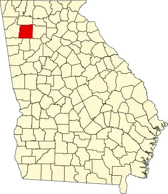
Bartow County
| County in de Verenigde Staten | |||
|---|---|---|---|
| |||
| Situering | |||
| Staat | Georgia | ||
| Coördinaten | 34°14'24"NB, 84°50'24"WL | ||
| Algemeen | |||
| Oppervlakte | 1.218 km² | ||
| - land | 1.190 km² | ||
| - water | 28 km² | ||
| Inwoners (2000) |
76.019 (64 inw./km²) | ||
| Overig | |||
| Zetel | Cartersville | ||
| FIPS-code | 13015 | ||
| Opgericht | 1832 | ||
| Website | www | ||
| Foto's | |||
| |||
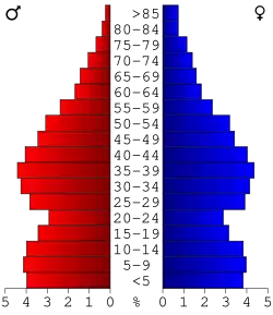 Bevolkingspiramide Bartow County | |||
| Statistieken volkstelling Bartow County | |||
| |||
Bartow County is een county in de Amerikaanse staat Georgia.
De county heeft een landoppervlakte van 1.190 km² en telt 76.019 inwoners (volkstelling 2000). De hoofdplaats is Cartersville.
Bevolkingsontwikkeling
| Jaar | Inwoners | % ± | |
|---|---|---|---|
| 1900 | 20.823 | — | |
| 1910 | 25.388 | 21,9% | |
| 1920 | 24.527 | −3,4% | |
| 1930 | 25.364 | 3,4% | |
| 1940 | 25.283 | −0,3% | |
| 1950 | 27.370 | 8,3% | |
| 1960 | 28.267 | 3,3% | |
| 1970 | 32.663 | 15,6% | |
| 1980 | 40.760 | 24,8% | |
| 1990 | 55.911 | 37,2% | |
| 2000 | 76.019 | 36,0% | |
| Bron: (en) Historical Decennial Census Population | |||
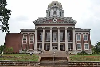
Foto's
-
 Voormalige rechtbank
 -
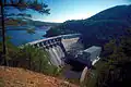 Allatoona Dam en naastgelegen meer
Zie de categorie Bartow County, Georgia van Wikimedia Commons voor mediabestanden over dit onderwerp.