Barber County
| County in de Verenigde Staten | |||
|---|---|---|---|
| |||
| Situering | |||
| Staat | Kansas | ||
| Coördinaten | 37°5'36"NB, 98°56'42"WL | ||
| Algemeen | |||
| Oppervlakte | 2.942 km² | ||
| - land | 2.937 km² | ||
| - water | 5 km² | ||
| Inwoners (2000) |
5.307 (2 inw./km²) | ||
| Overig | |||
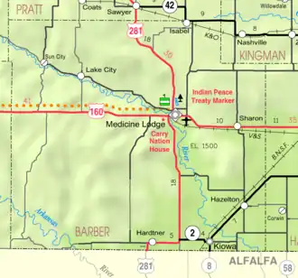
| Zetel | Medicine Lodge | ||
| FIPS-code | 20007 | ||
| Opgericht | 1867 | ||
| Website | barbercounty | ||
| Detailkaart | |||
| |||
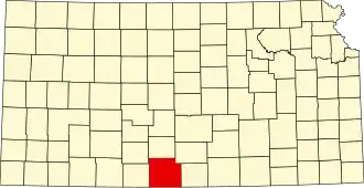
| Overzichtskaart van Barber County | |||
| Foto's | |||

| |||
 Bevolkingspiramide Barber County | |||
| Statistieken volkstelling Barber County | |||
| |||
Barber County is een county in de Amerikaanse staat Kansas.
De county heeft een landoppervlakte van 2.937 km² en telt 5.307 inwoners (volkstelling 2000). De hoofdplaats is Medicine Lodge.
Bevolkingsontwikkeling
| Jaar | Inwoners | % ± | |
|---|---|---|---|
| 1900 | 6.594 | — | |
| 1910 | 9.916 | 50,4% | |
| 1920 | 9.739 | −1,8% | |
| 1930 | 10.178 | 4,5% | |
| 1940 | 9.073 | −10,9% | |
| 1950 | 8.521 | −6,1% | |
| 1960 | 8.713 | 2,3% | |
| 1970 | 7.016 | −19,5% | |
| 1980 | 6.548 | −6,7% | |
| 1990 | 5.874 | −10,3% | |
| 2000 | 5.307 | −9,7% | |
| Bron: (en) Historical Decennial Census Population | |||