Adair County (Kentucky)
| County in de Verenigde Staten | |||
|---|---|---|---|
| |||
| Situering | |||
| Staat | Kentucky | ||
| Coördinaten | 37°6'36"NB, 85°16'48"WL | ||
| Algemeen | |||
| Oppervlakte | 1.068 km² | ||
| - land | 1.054 km² | ||
| - water | 14 km² | ||
| Inwoners (2000) |
17.244 (16 inw./km²) | ||
| Overig | |||
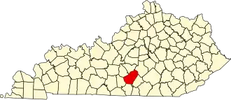
| Zetel | Columbia | ||
| FIPS-code | 21001 | ||
| Opgericht | 1801 | ||
| Website | www | ||
| Foto's | |||

| |||
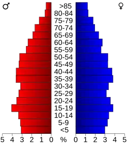 Bevolkingspiramide Adair County | |||
| Statistieken volkstelling Adair County | |||
| |||
Adair County is een county in de Amerikaanse staat Kentucky.
De county heeft een landoppervlakte van 1054 km² en telt 17.244 inwoners (volkstelling 2000). De hoofdplaats is Columbia.
Bevolkingsontwikkeling
| Jaar | Inwoners | % ± | |
|---|---|---|---|
| 1900 | 14.888 | — | |
| 1910 | 16.503 | 10,8% | |
| 1920 | 17.289 | 4,8% | |
| 1930 | 16.401 | −5,1% | |
| 1940 | 18.566 | 13,2% | |
| 1950 | 17.603 | −5,2% | |
| 1960 | 14.699 | −16,5% | |
| 1970 | 13.037 | −11,3% | |
| 1980 | 15.233 | 16,8% | |
| 1990 | 15.360 | 0,8% | |
| 2000 | 17.244 | 12,3% | |
| Bron: (en) Historical Decennial Census Population | |||